Downscaling
Global ClimateClimate
Climate in a narrow sense is usually defined as the average weather, or more rigorously, as the statistical description in terms of the mean and variability of relevant quantities over a period of time ranging from months to thousands or millions of years. The classical period for averaging these variables is 30 years, as defined by the World Meteorological Organization. The relevant quantities are most often surface variables such as temperature, precipitation and wind. Climate in a wider sense is the state, including a statistical description, of the climate system. Models (GCM) provide projections of how the climate of the Earth may change in the future. These results are the main motivation for the international community to take decisions on climate changeclimate change
Climate change refers to a change in the state of the climate that can be identified (e.g., by using statistical tests) by changes in the mean and/or the variability of its properties, and that persists for an extended period, typically decades or longer. Climate change may be due to natural internal processes or external forcings such as modulations of the solar cycles, volcanic eruptions and persistent anthropogenic changes in the composition of the atmosphere or in land use. Note that the United Nations Framework Convention on Climate Change (UNFCCC), in its Article 1, defines climate change as: 'a change of climate which is attributed directly or indirectly to human activity that alters the composition of the global atmosphere and which is in addition to natural climate variability observed over comparable time periods'. The UNFCCC thus makes a distinction between climate change attributable to human activities altering the atmospheric composition, and climate variability attributa mitigation. However, the impacts of a changing climate, and the adaptationadaptation
The process of adjustment to actual or expected climate and its effects. In human systems, adaptation seeks to moderate harm or exploit beneficial opportunities. In natural systems, human intervention may facilitate adjustment to expected climate and its effects. strategies required to deal with them, will occur on more regional national scales. DownscalingDownscaling
Downscaling is a method that derives local- to regional-scale (10 to 100 km) information from larger-scale models or data analyses. Two main methods exist: dynamical downscaling and empirical/statistical downscaling. The dynamical method uses the output of regional climate models, global models with variable spatial resolution or high-resolution global models. The empirical/statistical methods develop statistical relationships that link the large-scale atmospheric variables with local/regional climate variables. In all cases, the quality of the driving model remains an important limitation on the quality of the downscaled information. methods bridge the mismatch of spatial scale between the scale of global climate models and the resolution needed by decision-makers and impact assessors.
A Global Climate Model (GCM) can provide reliablereliable
A characteristic of a forecast system for which the probabilities issued for a specific event vary a proportion of times equal to the climatological frequency of the event. A reliable system which predicts, for example 50% (or 20%, or 73%) probability of rain ,should, on average, be correct 50% (or 20%, or 73%) of the times, no more, no less.
prediction information on scales of around 1000 by 1000km covering what could be a vastly differing landscape (from very mountainous to flat coastal plains for example) with greatly varying potential for floods, droughts or other extreme events. Downscaling is a method that derives local to regional scale (10 to 100 km) information from larger-scale models or data analyses. Two main methods exist: dynamical downscaling and statistical downscaling. These applied over a limited area and driven by GCMs can provide information on much smaller scales supporting more detailed impact and adaptation assessment and planning, which is vital in many vulnerable regions of the world.
Dynamical downscaling
Nesting a regional climate model into an existing GCM is one way to downscale data. To do this, a specific location is defined and certain driving factors (temperature, wind etc.) from the GCM are used as input at the boundaries of the domain simulated by a regional climate model (RCM). A regional climate model is a dynamic model, like a GCM, having its own physics based equations to resolve the model, based on data from the GCM but also on additional locally specific data.
RCMs can resolve the local small scale information about orography (land height), land use etc., providing weather and climate information at resolutions less than 50 or even 10 km. More recently, RCMs are used also in coupled systems, i.e. atmospheric models with other earth process models, such as hydrology, ocean, sea-ice, chemistry/aerosol and land-biosphere models. The results are local predictionspredictions
is generally used as a synonym of forecast . At the same time some authors like to use prediction in a more general sense while referring to forecasts as to a specific prediction which provides guidance on future climate and can take the form of quantitative outcomes, maps or text.
that are informed by both local specifics and global models. This process requires significant computational resources because it is dependent on the use of complex models.
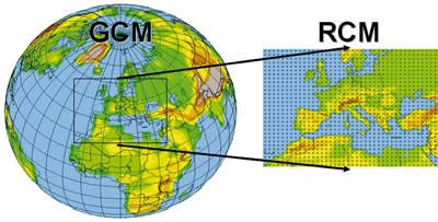
RCM domain embedded in a GCM grid. Source: F. Giorgi, WMOWMO
World Meteorological Organisation Bulletin 52(2), April 2008.
Statistical downscaling
A second way of downscaling climate data is through the use of statistical methods. There are a variety of such methods ranging from multiple regressions that link local variables to particular drivers in GCMs, to more complex methods using statistics designed for neural networks. The general strategy of these methods is to establish the relationship between large scale variables, such as the driving factors derived from GCMs, to local level climate conditions. Once these relationships have been developed for existing conditions, they can be used to predict what might happen under the different conditions indicated by GCMs.
Developing a statistical downscaling model is usually quite time-intensive and requires very extensive observational data - daily/hourly weather data, for the surface and maybe for the upper air, and usually for several sites or grid-boxes covering the region of interest. Also most downscaling methods and models are developed with a specific application in mind - whether agriculture, forestry, water, etc. - and quite often for a specific geographic region. Not all downscaling methods can easily be transported from one region to another.
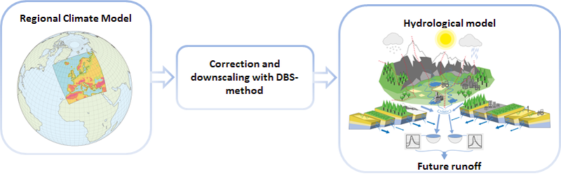
Example of a statistical downscaling method for hydrological impact studies Source: Yang et al., 2010