Climate models
The behaviour of the climate systemclimate system
The climate system is the highly complex system consisting of five major components: the atmosphere, the hydrosphere, the cryosphere, the lithosphere and the biosphere, and the interactions between them. The climate system evolves in time under the influence of its own internal dynamics and because of external forcings such as volcanic eruptions, solar variations and anthropogenic forcings such as the changing composition of the atmosphere and land use change., its components and their interactions, can be studied and simulated using climate models. A climate model is usually a 3-dimensional description of the atmosphere, land surface, ocean, lakes and ice expressed in numerical terms. They discretise and solve the full equations for mass and energy transfer and radiant exchange within the Earth’s climate system on a grid with finite resolutionresolution
In climate models, this term refers to the physical distance (meters or degrees) between each point on the grid used to compute the equations. Temporal resolution refers to the time step or the time elapsed between each model computation of the equations. around the globe. However, many physical processes, such as convection, also occur at scales smaller than the minimum grid size and cannot be properly modelled. Instead, their known properties must then be averaged over the larger scale in a technique known as parametrisation.
Numerical climate models are the most advanced tools currently available for simulating the response of the global climate system to increasing greenhouse gas concentrations.
Global climate models cover the whole globe but have limited spatial and temporal resolution. To get more detailed data for a specific area a regional climate model is applied, using the boundary conditions from the global model and a more detailed land cover, and producing data with higher spatial resolution.
Global climate models
Global Climate Models or General Circulation Models (GCMs) are based on the general physical principles of fluid dynamics and thermodynamics. They originate from numerical weather prediction models and describe the interactions between components of the global climate system. GCMs develop as the scientific understanding of the climate system increases. Enabled by increased computational resources the models get more and more complex, the descriptions of processes become more detailed and further components of the climate system are included.
Models today are developed to include components and processes apart from the physical atmosphere-ocean components. The vocabulary is shifting from GCMs to Earth System ModelsEarth System Models
The scientific knowledge has now progressed to the level where global climate models are being replaced by Earth System Models signifying that the models now embrace more components and processes than the physical atmosphere-ocean components traditionally used to describe the climate. For a detailed inventory and/or comparison of the various Earth System components in any of the current generation of GCMs please refer to Comparator. (ESM) as a sign of this development. ESMs include physical processes like those in other climate models but they can also simulate the interaction between the physical climate, the biosphere, and the chemical constituents of the atmosphere and ocean. ESMs include processes, impacts, and complete feedback cycles.
Climate modelling demands a lot of computer resources. Even though computing capacity increases constantly, the calculations in the global models are still made with a rather course grid, typically having a horizontal resolution of between 250 and 600 km, 10 to 20 vertical layers in the atmosphere and sometimes as many as 30 layers in the oceans. The details on local or regional level are thus quite low and not suitable for most impact assessments.
Regional climate models
A limitation of GCMs is their fairly coarse horizontal resolution. For most impact studies, such as evaluation of the future risks of floods or some types of landslides, droughts etc., society requires information at a much more detailed local scale than provided by GCMs. A common method is to embed a regional climate model (RCM) of higher resolution in a relevant part of a GCM domain.
In a RCM a three-dimensional grid is defined over a relevant area, such as Europe, Africa or the Arctic. The consideration of a smaller area allows a much denser grid compared to the GCM grid. What is simulated outside the calculation area of a regional model is determined by the global model; in this way processes outside the RCM area are taken into account. When results from global modelling are used in regional modelling, this is called ‘regional downscaling’.
RCMs are complementary to GCMs by adding further details to global climate projections. RCMs can resolve information about land height and land use in more detail than the GCMs. RCMs usually have a 3-dimensional grid with horizontal resolutions between 50 and 12.5 km. Research is developing towards higher resolutions, but these models are highly demanding on computer resources.
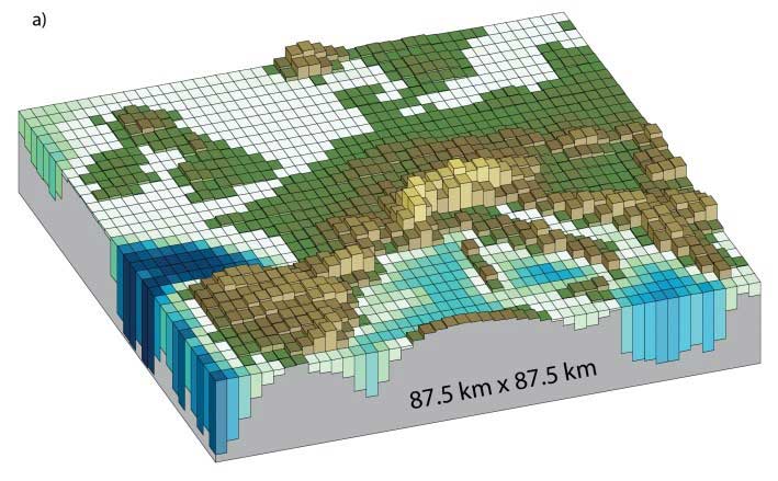
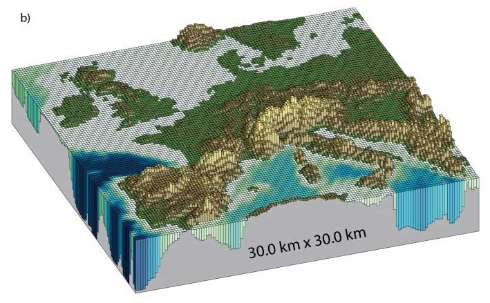
Horizontal resolutions considered in models now being tested: (a) Illustration of the European topography at a resolution of 87.5 × 87.5 km (higher resolution than most current global models); (b) same as (a) but for a resolution of 30.0 × 30.0 km (similar to the current regional climate models)
source: IPCC-AR5, WG1,Chapter1, 2013